In today’s society, millennials often take many of the tools around them for granted. The various digital networks and technological tools that the millennial demographic has access to were not around even two decades ago. The world has seen a rapid cultural shift towards a global network, connected by individual users forming their own links that can be understood in spatial context. The expansion of the network has welcomed input from individuals of all backgrounds. Academics, politicians, and governments are no longer the only ones who can submit geographic information. Places on the map now come from everywhere. One of the best examples of the inclusion of the global “public” in creating and maintaining networks can be seen with the development of the hand-held Global Positioning System (GPS). Specifically, the most recent phenomenon of “geotagging” has created a cartographic culture among civilians that contradicts the history of cartography, in which maps were valuable symbols of power. The age of digital media and culture has led to an unprecedented shift in cartography and maps, which has turned the individual into an influential contributor to maps.
Prior to the discovery of the new world, Europeans with geographic knowledge and cartographic skills were valuable. Maps were symbols of great power and superior knowledge. The Royal Geographic Society of the United Kingdom sponsored expeditions for ambitious explorers to survey the land and create maps of the new world. Those explorers could choose the way the lands were portrayed along with deciding what to include and omit. Fast-forward over a century and the map is a changed tool. MapQuest and Google allow a user to have step-by-step directions personalized for the user’s route. The user can select from 2-3 choices of routes and print out the directions for a trip. An individual no longer needs giant, folding paper maps that sit in glove compartments for instances when street signs failed. Instead, each traveler has an individual map catered to his or her own needs.
The GPS was created by the Department of Defense as a network of 24 satellites that were used in World War II. Originally, the highest quality signal was only available to military personnel because the program was not designed for civilian use. As it became increasingly useful, the GPS has grown in its capabilities to meet the rising demands of military, civil, and commercial uses. Compared to its original intentions, the GPS feature has had an unprecedented influence on cartographic power and consumer behavior.
As technology improves, so does the quality and accessibility of GPS. Smartphones are more widespread now than ever. Almost all smartphones have GPS devices inside, which has had incredible implications for the mapping world. Geographic data files contain metadata, which is essentially data about the data – i.e. where it came from, when it was made, who made it, etc. Traditionally, metadata comes from a source such as the US Geological Survey (USGS), Environmental Systems Research Institute (ESRI) or other equivalent organization. The rise of Google Maps and Google Earth has allowed civilians to essentially become their own cartographers and map their own lives. Civilians are now creating the metadata themselves.
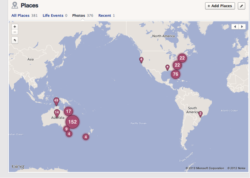
“Geotagging” is the most recent smartphone innovation that links social media networks to a user’s location, so that pictures are catalogued with a date, a time, and a place. Facebook profiles now have dynamic maps where friends can view all of the places that you have visited and the pictures you took at those locations. For example, check out the image below. That’s the “map” from my Facebook. With just a screenshot, anyone of my friends can pretty much figure out where I have been for the past three years without me having to tell a single story. Click further on the page and a friend can zoom in to see where I attend college, where I went abroad, what I did for spring break, and what my favorite venues are in Richmond.
Facebook messages now indicate the user’s location, including distinguishing whether the user is “mobile” or “web.” Tweets are also linked to a user’s GPS (unless location settings are turned off), meaning that live updates allow followers to see exactly where the user is. All of these pictures and notes that are connected to locations are part of the metadata for that given point, which corresponds to coordinates on the map.

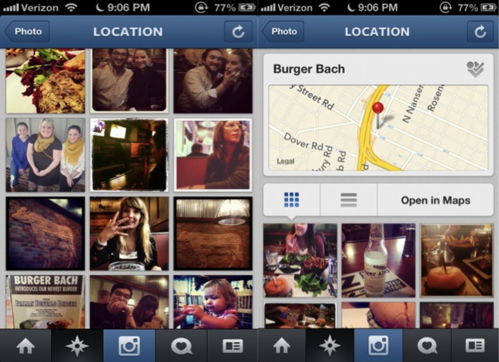
The concept that civilians with little knowledge of geographic information can change a global map is powerful. Anyone can log onto Google, look at the interactive map, and submit a new location. This revolutionized geographic world of dynamic and interactive maps has influenced many aspects of society, including consumerism. People are sharing knowledge and information about places that encourages viewers to go to those spots. When a user sees pictures of friends on vacation, he or she might make the association of enjoyment and a particular place. An Instagram picture of food from a trendy NYC restaurant encourages other users to want that same experience. The geotag feature allows users to catalogue themselves and share that information with others. On Instagram, a user can click on a geotagged location and scroll through all the pictures taken at that location by other users. The two images below are screenshots from geotag on a restaurant in Richmond, VA. A friend of mine recently went there and tagged “Burger Bach” on her photo of a delicious looking burger. When I clicked on the restaurant, I instantly saw its location, the option to check-in on FourSquare, and all these photos of random people enjoying fabulous food. These people, whether knowingly or not, have contributed to the metadata surrounding Burger Bach. Those photos that captured experiences are now projected as part of the Burger Bach experience.
In other examples, the civilian has the ability to change a road map or submit a traffic update. Many traffic apps for cell phones have a component that allows users to make a note of where the traffic is or how to avoid a roadblock. The ability for this information to be updated in real time has been efficient and helpful for travelers.
Geography is now a field that is integrated across almost every discipline. Geotags and hand-held GPS features have given the average civilian more power than ever before. In the past, cartographers would not have accepted help or information from just anyone. The digital age represents a turning point for cartography. Many millennials have been amateur geographers already by linking their experience in a space to a particular location and then tagging a picture to share with the rest of the community. People should take advantage of these new opportunities to make a difference. After last year’s tragedies in Boston, Google promptly released an application, Google Person Finder, which allowed users to log their name and location or report information on someone else. People could then type in a name to check in on a friend or family member and ensure safety or take action if a person was believed to be missing or in danger. Additionally, a GoogleDoc was passed around over Facebook and news media to offer locations with housing for those affected by the tragedy. These two recent examples show the potential benefits for using the hive mind for problem solving and assistance. With the capabilities of personal GPS and news media, normal people were able to save lives and offer support.

- The article “Web Photos That Reveal Secrets, Like Where You Live” explores the geotagging of photographs and exposes potential security concerns.
- The website ICanStalkU.com provides instructions for disabling geotagging settings on smartphones.
- The article “How Google Builds Its Maps—and What It Means for the Future of Everything” examines Ground Truth, a project devoted to building the world’s most accurate maps.

Celia Landesberg
is a senior at the University of Richmond double majoring in Environmental Studies and Geography. Born and raised in the suburbs of New York City, Celia enjoys traveling and is looking to relocate to a new city after graduation. Celia is passionate about sustainability and climate change and plans to pursue those interests as a career path.
:::


